The town of Korčula is located in Croatia (on the eponymous island of Korčula) and has a little over 3,000 inhabitants.
It was founded in the 4th century BC, during Greek antiquity, to house a colony.
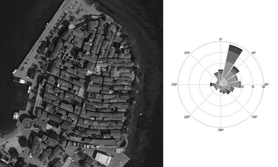
The old centre of Korčula is distinguished by a characteristic urban form: the very narrow side streets are arranged in a herringbone pattern on either side of a central axis that crosses the entire old town.
The buildings that are very close to each other are almost all oriented along the east/west axis (left image).
When looking at the annual wind rose of the nearest station to the site (Ploce town), the usefulness of this urban morphology is evident (right image).
The buildings are mainly oriented perpendicular to the prevailing north-northeast winds and interspersed with narrow, sheltered streets.
This urban form probably reduces losses for heating buildings and external thermal discomfort of pedestrians.
All this should be confirmed by simulations.
It can also be assumed that the wind speed is maximum at the outskirts of the town, as it crosses the sea which has very low roughness.
The old centre of Korčula literally turns its back on the prevailing winds and takes the form of an arch surrounded by wide ramparts and open to the south.
Of course, in the absence of ancient written documents that attest that the town's layout was designed according to the wind, we are reduced to making assumptions and observing after the fact.
This is the whole problem with the bioclimatic study of vernacular architecture.
But studying past developments according to their climatic function is deeply fascinating!
Sources: A. Guyot, @15lovetennis
Photos:
- Vidmantas Patamsis
- CBE Clima Tool